
Value of mapping for farm businesses
It may seem obvious, but knowing exactly what land you own or farm, and particularly where your boundaries are, is a pre-requisite for effective management. In many cases the situation isn’t as clear cut as people think.
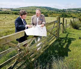
At the most basic level, an up-to-date digital map showing boundaries accurately and reflecting the actual position of features on the ground allows you to protect your property interests efficiently.
However, as well as boundaries, land use, parcel areas, rights of way, legal ownership, occupation, cropping, sporting interests, utilities, neighbouring owners and environmental constraints all need to be clearly recorded.
Most of the boundary issues we are asked to look at involve parties where both properties are registered. So although land registration is an essential element in safeguarding your property, you should not assume that your plans accurately reflect current boundaries on the ground if the process was carried out some time ago.
Spotting encroachment
While the position of many boundaries such as fences or a wall will be obvious, there is not always a clear physical line in place. Gradual encroachment, dumping and access issues are not uncommon where farms and estates adjoin residential gardens.
A complete map of your holding, enabling it to be seen in the context of its surroundings, is also vital for strategic planning, which may include tax planning. This is particularly useful if multiple Land Registry plans are involved. It allows you to see how potential acquisitions could complement your existing management, as well as identifying parcels of land that could have development value in the future.
Development value
With development sites selling for hundreds of thousands of pounds an acre, losing or gaining a few metres here or there along the length of a field could make a significant difference to the value.
Even maps based on relatively recent Ordnance Survey (OS) data may not be reliable for the exact answer. When the OS remapped its entire rural 1:2,500 scale data around six years ago, some boundaries shifted by as much as 9m, with the average move being almost 2m.
Many farm offices that have mapping software are still using older OS data in a bid to save money. In doing so there could be licensing issues and any areas measured for grants and subsidies, cropping, sales and so on will be incorrect.
Up-to-date mapping can also assist in dealing with subsidy claims and help to speed up property transactions. Often, the process of selling or buying land or property will flag up poorly defined plans and/or boundaries. By then, however, it can delay proceedings considerably and even scupper a deal.
Manorial and sporting rights
Many farms and estates also have wider manorial and sporting rights that require mapping. Tracking down the exact boundaries of these can involve a lot of detective work, but is worth it as some of the rights can be very valuable.
If you think you own any manorial rights over land that you no longer hold with vacant possession, these have to be registered by 12 October 2013 to avoid losing your overriding interest in them.
What’s involved in mapping?
- New maps can often be created remotely without a need to visit the property – copies of title deeds and any other existing maps are often all that will be needed
- If the entire process can be done remotely, it is possible to map a small farm in a day and a large holding or estate in less than a week
- How long the process takes depends on the size of the property, how much detail is required and how much work is needed on the ground
- If physical checks are needed on poorly defined or contentious boundaries, the process will take longer
- If the latest OS data or aerial imagery does not actually reflect the land use features on the ground, these may need to be surveyed
- Costs vary depending on the involvement and level of detail required – fees vary from 50p to £3-plus/acre
- Once your up-to-date plan is complete, training will ensure you get the most from a new map, mapping software and data.
Mapping survey
How accurately is the UK’s rural property mapped? What boundary issues do landowners regularly face? Knight Frank is running an online survey until 31 March to get answers to these questions. To take part visit the Knight Frank website.
Completing the survey takes just a few minutes and all respondents will be entered into a draw to win a bespoke map of their farm or other mapping services up to the value of £1,000.
RPA rolling out new mapping system