
GPS: what it is and how it can help you
 With this year’s Precision Farming 2008 Event taking place near Peterborough on 5 March, Peter Hill provides some back-to-basics information for those wanting to join the GPS club.
What is GPS?
The Global Positioning System uses 24 satellites originally launched in the 1990s by the US military to pinpoint the location of its vehicles on the ground. Time signals from at least four satellites at any one time are used by a vehicle-mounted receiver to calculate its location.
What about dGPS?
Atmospheric effects and mathematical inaccuracies mean a correction mechanism is needed to achieve the sub-1m accuracy required for agricultural applications. Differential GPS calculates the difference between the location of a fixed-position ground station and where the satellite signals say it is. Correction data are then sent to the vehicle’s GPS receiver.
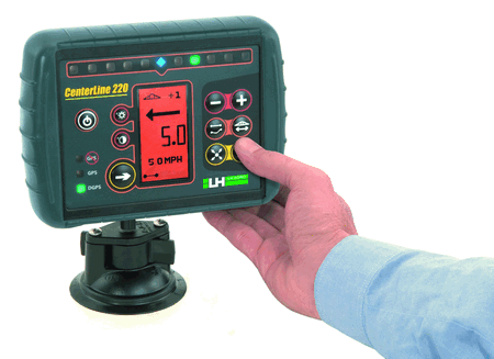
What equipment do I need?
A roof-mounted antenna, a receiver in the vehicle cab (to unscramble the GPS signal) and a display. You’ll also need access to a correction signal, which in Britain includes the new European service EGNOS and commercial services provided by Omnistar and John Deere.
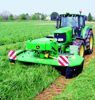
Look, no hands! Fully automatic guidance relieves the driver of having to concentrate on steering while making the most of implement width and ensuring ‘lands’ are cut in regular blocks.
What can I use GPS for?
Mapping the boundaries of fields, calculating the area they cover, providing “markers” for representative soil sampling, recording drainage problems, weed mapping, and recording crop yield variations across a field.
What about implement control?
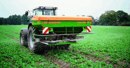
GPS-compatible controllers can operate a sprayer, spreader or drill to work according to an application map, automatically switching between two, three or more different rates, or only working in selected areas of a field. They can also switch the machines on and off at headlands and close down the working width in irregular-shaped areas. Work-done records can be created for farm assurance purposes and for management analysis.
What about guided or automatic steering?
This is one of the fastest-growing uses of GPS technology. Steering guidance shows where the driver should steer to work across a field in parallel passes at the spacing required by the implement. Automatic steering does everything – it provides a display but also steers the vehicle.
What vehicles can I use it on?
Guidance and auto steering are most commonly used on tractors but also on self-propelled sprayers and spreaders, combines and forage harvesters and self-propelled mowers.
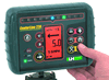
Some of the displays on GPS equipment are getting very sophisticated, with colour, 3D view and graphics to warn you if you are going off-beam.
I’ve got tramlines, why do I need guidance?
First, for where there are no tramlines – pre-emergence spraying, autumn fertiliser and lime spreading, spraying and spreading on grass. Then there’s drilling, which marks out the tramlines in the first place.
I’ve got good eyesight, I can steer accurately myself.
Maybe, but drivers tend to overlap more than necessary to avoid misses, and that means lost productivity. In trials with a 33m sprayer, an experienced operator averaged 5m over- and under-lapping. That’s almost 15% of the working width. Foam markers and headland flags reduce this to 90cm and 70cm, visual guidance to 19cm and auto steering to an average deviation of just 7cm. You can also work much more accurately in the dark.
What do you do first time in the field?
Once you’ve entered the implement working width you manually drive a straight line across the field, recording the start and finish points. The unit then creates parallel lines to left and right across the field.
I don’t want anything too technical or expensive how about just guidance?
It’s certainly the simplest and cheapest option because nothing’s done to the vehicle itself, apart from mounting an antenna and receiver/display unit. In some cases, the monitor bought with the tractor can be used.
What should I be looking for?
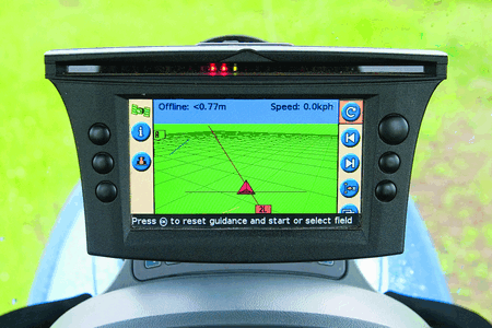
A lightbar display is usually the cheapest. It has a series of coloured lights to show whether you’re on target or should steer left or right. Some designs also indicate the vehicle’s heading so you know how much correction is needed. The alternative is a graphic display (which sometimes comes with a lightbar as well) showing a guide line and the tractor’s position relative to it as well as advising where to steer.
It’s just a matter of preference, then?
Both are fine if you don’t need to be spot-on accurate all the time, but the graphic display units usually provide additional features, such as showing where you’ve already been with an implement.
Is a hands-off auto steering system more accurate?
It should be, because it doesn’t rely on the operator interpreting the display. But the real advantage is the way it relieves the driver of having to concentrate on steering. Instead, he can focus on what the machine’s doing and how it’s performing.
There are typically three main levels of GPS accuracy – sub-20cm, sub-5cm and sub-2cm.
What’s available for auto steering?
There are two approaches: Assisted steering replaces the standard steering wheel with a powered version or involves fitting a drive mechanism to the existing steering wheel. Integrated auto steering upgrades the vehicle’s steering mechanism with an electrically-operated control valve and sensors on the front axle that constantly report the angle of the wheels.
Are they as good as each other?
Assisted steering is a relatively quick and inexpensive way of adapting an existing vehicle to GPS automation but it relies on the standard steering mechanism. Integrated auto steer is more sophisticated and should be a better bet for the greatest accuracy.
What about the accuracy of the GPS system itself?
There are typically three levels of dGPS accuracy – base-level giving an accuracy tolerance of +/-20cm mid-level with +/-5cm accuracy and top-level, commonly referred to as “RTK'” accurate to within +/-2cm.
How do I choose what level of accuracy I need?
Depends what you want it for. First-level accuracy would be fine to get visual guidance or auto steering for a wide cultivator. Mid-level accuracy would be better for spraying, drilling and row-crop work. Top-level accuracy is best for bedforming, as well as being desirable for spraying, drilling and similar work.
How are the different levels of accuracy achieved?
The two levels of non-RTK accuracy are achieved by controlling the amount of correction data made available. While base-level accuracy can be achieved with a single-frequency receiver, greater accuracy requires a dual-frequency receiver and a licence. The quality of the receiver is also a factor. For top-level accuracy, the RTK (Real Time Kinematics) set-up includes a base station on the farm, which comprises a dGPS receiver and radio transmitter to give a very local correction signal.
Does the “RTK” base station go on the vehicle or somewhere else?
It can be mounted on a tripod near the field being worked or, ideally, high up on a barn roof.
Would I need one of these stations for every vehicle using GPS?
No, one transmitter can be used with several vehicles up to five or six miles away.
Remember trees, hills and buildings will affect signal reception when the tractor moves into their shadow but more sophisticated systems will be able to compensate.
A light-bar is one of the cheapest ways of getting into GPS guidance and will help you drive more accurately.
Is cloud a problem?
Cloud and rain won’t affect the signals but they can be affected by atmospheric conditions and by the position of the GPS satellites.
Do you always have to work in straight lines?
Not necessarily many guidance and auto steering systems will follow a curved guide line and settings can be adjusted so that the tractor steers correctly for the trailing characteristics of any towed implement. Higher spec systems can handle hills, too.
What do all these different systems cost?
Visual steering guidance equipment costs between £1200 and £1800 for a lightbar and from £1400 to £2500 for a graphic display unit. Assisted steering comes in at between £4500 and £7000, while integrated auto steering will cost from £7000 to £15,000. On a growing number of tractors and combines, the wiring is installed as standard, which is bringing the initial cost down.
Do you have to pay for the GPS service?
Access to the raw GPS signal is free. The European EGNOS correction service is also free, as is the StarFire SF1 correction from John Deere for its receivers. The equivalent Omnistar VBS service costs £591/yr with discounts for multi-year contracts. The higher-accuracy Omnistar XP licence is £889/yr. Omnistar’s HP regional licence is £1186 annually, with the equivalent StarFire 2 licensed at £745 annually.
So I could spend £15,000 or more just for the tractor to steer itself?
Yes, but think of the benefits. It’s all about improving productivity and minimising wastage, as well as making life more comfortable for the driver. Improving pass-to-pass accuracy with the 33m sprayer described earlier cut the cost of wasted glyphosate from £2.60/ha with no guidance to just 3p/ha with auto steering. Other calculations suggest a potential £18/ha (£7.50/acre) saving on forage crop fertilisers and that the cost of a £20,000 system for auto steering on a tractor and combine could be recouped over 800ha (2000 acres) of combinable crops in just 12 months.
Can I keep the system when I sell the vehicle?
Visual guidance and assisted steering are easily transferable from one vehicle to another – so they can be shared between a tractor and combine – but realistically the hardware for an integrated auto steer system would need to stay on the vehicle. Still, it might improve its resale value.
Get free quotes from up to 6 Vehicle Tracking suppliers.
