
Mastenbroek and Trimble bring GPS to field drainage
Putting pipes deep below fields to improve drainage has always been a laborious business.
You have to survey the field carefully, work out your grade (ie the slope the drains will run at) and the trencher and pipelayer then have to work with considerable precision.
When laser technology came along in the mid-1970s, it allowed the man on the trencher to know the depth was being maintained very precisely. But the field still had to be laboriously surveyed first (which could take a day) and the laser technology had some serious shortcomings.
For a start, the flat, rotating beam emitted by the laser itself was limited to a range of 450m. Wind would make the transmitter shake and rain, fog and dust could all restrict its range.
There was also no way of automatically recording where you had laid the drains. A man with a recording wheel had to tramp back and forth over the field and then draw it all on a big sheet of paper back in the office.
But that’s all about to change. Lincolnshire firm Mastenbroek has just announced the first GPS-based system that offers the same degree of precision as lasers, but with some powerful advantages.
The system is based on a recently launched piece of Trimble GPS software called Fieldlevel II. This uses an RTK base-station to give an accuracy of +/-2cm not just in the X and Y planes but also in the trickier-to-deal-with Z plane – ie up and down.
 | |
|---|---|
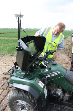
| ATV with GPS receiver and big screen surveys the field in two hours, compared to a day with the old system. |
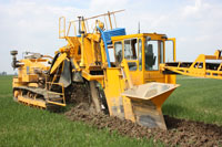
The GPS antenna simply slots in at the top of the trencher where the laser receiver normally fits.
What are the benefits? Field surveying times are slashed – an ATV fitted with a GPS receiver can survey 120 acres in two hours, producing a 3D map showing all the ups and downs of even the most undulating field. So any problems can be tackled before the trencher rumbles into action.
The depth of gravel can also be tailored according to whether there is a dip or a high point in the field above it. That means less gravel, which is an expensive input paid for directly by the farmer and can account for 50% of the cost of the work.
Another benefit is that the system automatically records every detail of the job done on Farm Works mapping software. So the farmer has an ultra-accurate field map of his land drains and, if the drainage contractor needs to add some extra drains at a later date, he knows exactly where to position them.
On top of that, Fieldlevel II needs no regular calibration (unlike laser-controlled machines) and is unaffected by wind, rain, fog or limited range.
Several units have been undergoing trials for the last eight months, including one being used by the Lincolnshire Drainage Company. “It’s a massive step forward,” says LDC’s David Firth. “It will make the job much more efficient for contractors.”
The new GPS system is now on sale and costs from £5000 for the basic mapping software up to £40,000 for the full depth control. Though designed to fit Mastenbroek’s own machines, it will be compatible with other trenchers, too.
Mastenbroek’s general manager Chris Pett is confident that GPS will catch on in the drainage world. “The old system was very time-consuming.” He says. “This will reduce labour input and administration hugely. One contractor told me he liked it because it’s so damn simple.”
This is a good time to be launching the new system too, he adds. After a run of years during which farmers had virtually no land drainage done, there’s a modest revival of interest.
“It’s chiefly the demands of growing root crops that are driving it,” he says. “British Sugar’s plans for just-in-time lifting will mean later lifting and that will affect that too. Heavier machinery and increasing extremes of weather are a factor too.”
