


Description
Excellent parcel of productive arable land set in the Lincolnshire Wolds with range of modern farm buildings.
Description
Introduction
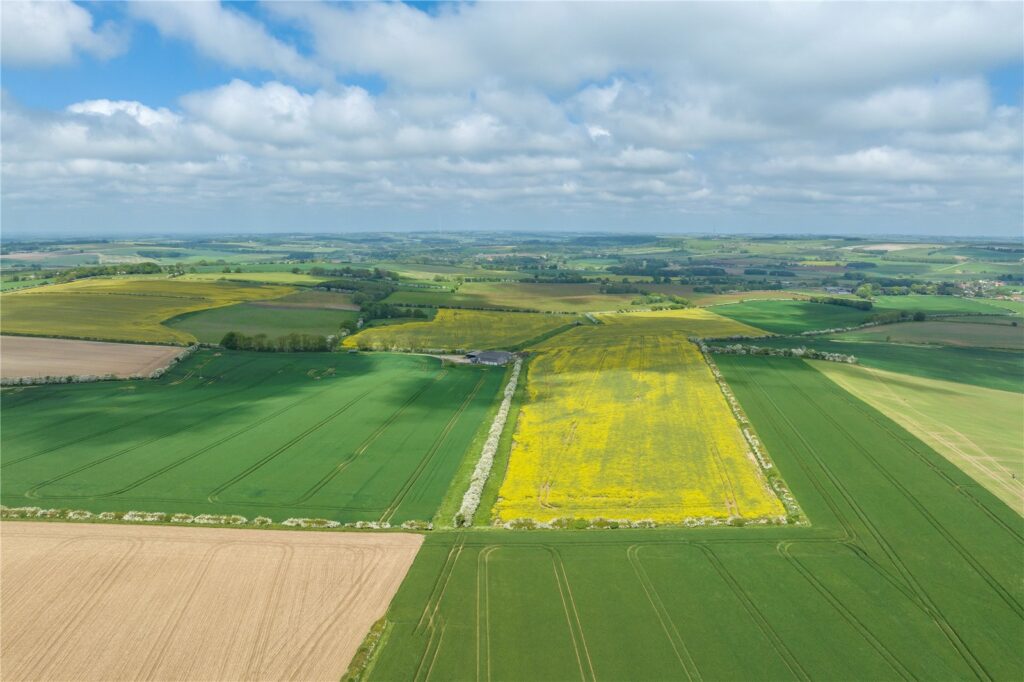
Manor Farm extends to about 292.79 acres (118.49 hectares)
of Grade 2 & 3 arable land. A productive ring fenced block, could be farmed standalone utilising the range of farm buildings, or be an addition to an existing holding. The property is located in a productive farming area within the Lincolnshire Wolds. Vacant possession will be available following termination of the current tenancy on 30th August 2023.
Situation
The land is located to the south of the village of Scamblesby,
in the Lincolnshire Wolds Area of Outstanding Natural Beauty.
The property lies almost equi distance between Horncastle and Louth, two delightful market towns both of which have a wide variety of amenities including shops, restaurants and supermarkets. The land is accessed directly from the A153 that runs between Horncastle and Louth, providing onward access to the A16 in the north and A158 in the south. Lincoln has a greater range of amenities including a train station that offers regular services to London with direct trains, taking approximately 2 hours.
Description
The land is arranged in two blocks only divided by the A153 both are accessed directly from the road, the largest block extends to 171.43 acres (69.37 hectares). The smaller parcel of land extends to 121.36 acres (49.12 hectares) with the agricultural buildings being located on the smaller block of land. To the east the land gently undulates, the fields are of a good size and regular shape for modern farming practices, divided by well maintained hedgerows.
Buildings
The buildings are assessed via a private stone track with access directly from the A153, easily accessible for HGVs and large machinery. The buildings lie at the end of the track where the land opens out to a level area. Overall the buildings are in a good condition and have a concrete apron.
Grain Store steel frame, concrete floor and grain walling, cement fibre roofing and cladding, sliding doors to the front leading to a concrete apron. The store measures 17.25m x 21.50m.
Open Fronted Store concrete frame and floor, thrust grain walling and cement fibre roofing and corrugated steel cladding. This building is suitable for holding crops temporarily and measures 11.30m x 13.55m.
General Purpose Building steel frame, concrete floor, red brick walling on one side, thrust grain walling to the rear and concrete grain walling adjoining the grain store. Roller shutter door to the front and sliding doors to the rear and measures 13.35m x 22.08m.
There are two traditional red brick buildings, the larger of which has a cement fibre roof, while the other has concrete tiles. The larger building wraps round the side of the general purpose building it includes two cart sheds and an open fronted store, to the rear is a roller shutter door for access, the building extends to approximately 152.96 m2 gross internal area.
The smaller building is set to the north of the main yard and is a single storey building with timber stable doors. A section of the building has been converted to a chemical store with insulation across the walling and ceiling, the building in total extends to 67.55 m2 gross internal area. To the front of the building is a concrete pad with raised lip and stand pipe with water connection for filling a sprayer.
These traditional buildings offer scope for alternative uses should purchasers desire subject to the relevant permissions being obtained.
Agricultural Land
The land is classified as Grade 2 and 3 on the Agricultural Land Classification Maps with the soils forming part of the Swaffham Prior and Arrow soil series. The former is described as well drained, calcareous coarse and fine loamy soils with the latter described as deep permeable coarse loamy soils. The soils are productive and capable of producing high yielding crops in a variety of growing seasons.
The land is currently growing, spring and winter barley, winter
wheat and oil seed rape. The previous cropping history across
the land is available on request from the selling agents. The land rises to the A153 at a height of 135 meters, then on either side slopes away, with it undulating in certain areas. In
the centre of the larger block of land there are the remnants of a range of traditional buildings that have been removed with a hardcore pad being created, adjacent to the access track.
Drainage
Part of the farm is under drained, drainage plans are available on request. The land is subject to drainage rates payable to the Environment Agency.
Basic Payment Scheme
The land is registered on the Rural Land Registry, the outgoing tenant has claimed and will retain the 2023 Basic Payment (BPS) and any subsequent payments based on previous entitlements and historical claims. The ingoing purchaser will indemnify the vendor and existing tenant against any non-compliance from the date of completion.
Environmental Stewardship Scheme
The land is entered into a Mid Tier Environmental Stewardship
Agreement that commenced on 01/01/2023 and shall terminate
on 31/12/2027, any purchaser shall be obligated to take on this agreement going forward. The agreement encompasses a
number of multi year options including 4 6 metre buffer strips
on cultivated and land two year sown legume fallow. Further
details can be provided by the selling agents.
Acreage: 292 Acres