
For sale – Land at Donington, South Lincolnshire
POA - SALE
Description
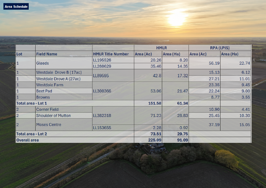
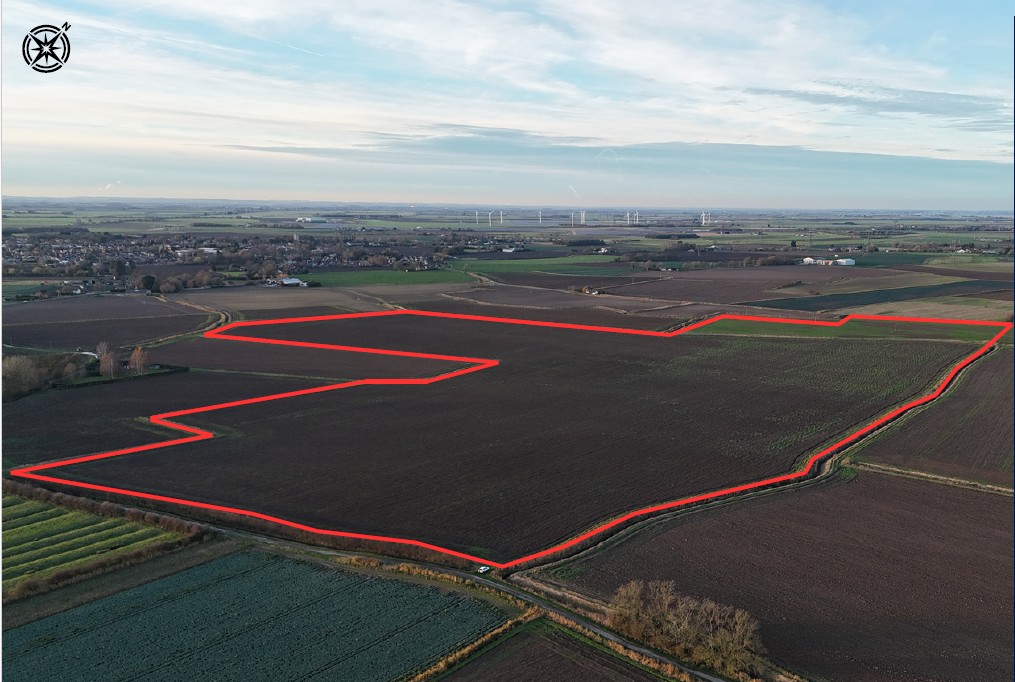
Two blocks of land comprising c. 91 Ha [225 acres] of highly productive Grade 1 and Grade 2 soils suited to vegetable, root and arable cropping
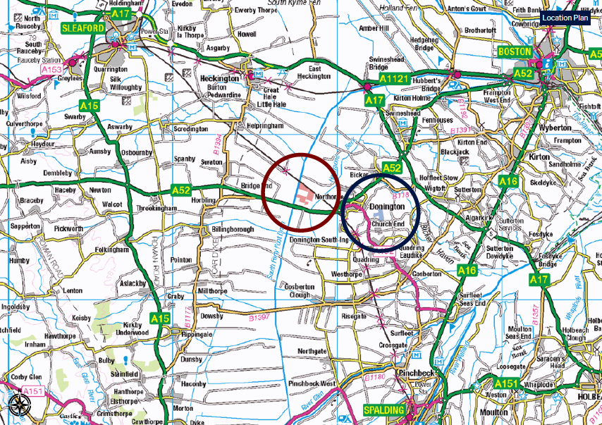
Located in and around Donington, South Lincs
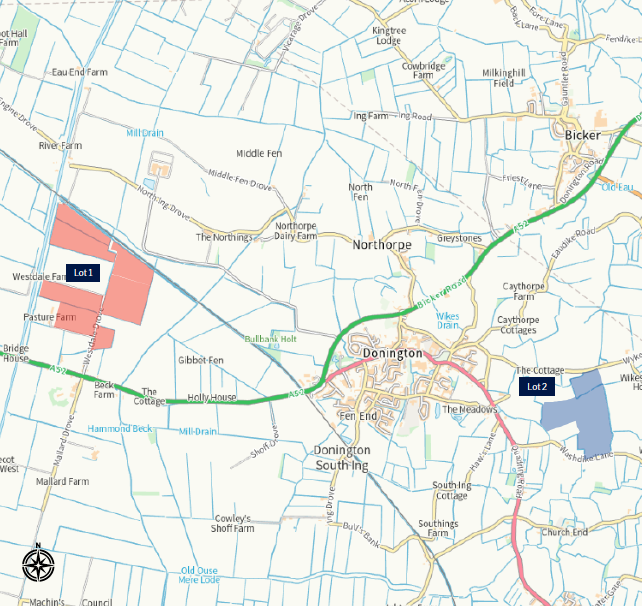
For sale by private treaty as a whole or in two lots
Guide Price Lot 1: £1,350,000 Lot 2: £925,000
Lot 1
151.58 acres | 61.34Ha Location
///lawns.enjoyable.cactus
Grade 2 arable farmland More detailed information is available in the farm data room.
Back Cropping
The back cropping is arable focused with a wide spread of combinable crops grown since the current owners took ownership, including: Winter Wheat Winter Barley Spring Barley Peas Oil Seed Rape SFI AB9 Option (The full back cropping history is in the data room along with a plan which shows the name of each field.)
Under Field Drainage
All fields have under field drainage. The age and specification varies from field to field. Please see the farm data room for the drainage plans and documentation.
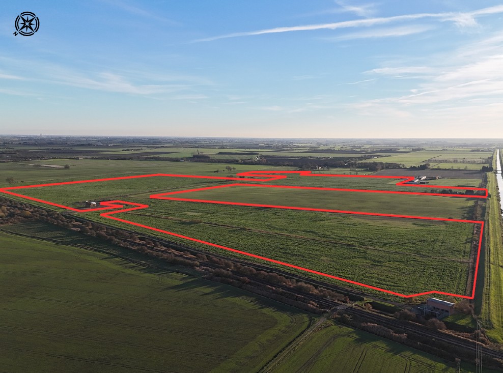
Lot 2
73.51 acres | 29.75Ha Location
///treatment.cost.combines
Grade 1 arable farmland More detailed information is available in the farm data room.
Back Cropping
Backcropping includes various combinable cereal crops as well as potatoes, sugar beet, brassicas, vining peas and sunflowers. (The full back cropping history is in the data room along with a plan which shows the name of each field.)
Under Field Drainage
All fields have under field drainage. The age and specification varies from field to field. Please see the farm data room for the drainage plans and documentation.
General Information
The contents of this section applies to both lots, unless the text specifically refers to an individual lot.
Lotting
The overall area is for sale in two lots. These are shown on the farm plan on the front cover of these particulars.
Lot 1 – c.61.95 hectares [153.08 acres] including Grade 2 arable land shown shaded pink on the farm plan.
Lot 2 – c. 29.75 hectares [73.51 acres] of Grade 1 arable land shown shaded blue on the farm plan.
Bids for the whole should be split between Lots 1 and 2.
Contracts and Quotas
Sugar beet has been grown on the farm for many years – the current contract is 1,500 tonnes PA. Purchasers should make their own enquiries to British Sugar.
Sporting
All sporting rights are included in the sale of the Property.
BPS | Entitlements
No right to any payments are included in the sale of the land.
Development Overage
Both Lots are being sold subject to an overage for any renewable energy development of 35% for 35 years.
Easements and Wayleaves
The land is sold with the benefit of and subject to all existing rights and obligations including rights of way, whether public or private, light, support, drainage, water and other obligations, easements, quasi-easements, and all wayleaves whether referred to or not in these particulars. Annual wayleave payments total to £685.64. Please see copies of the Payment Advices received for 2025 in the farm data room, along with copies of the Wayleaves agreements and the corresponding plans.
Utilities & Services
There is a water pipe that passes through Lot 1. The exact location is unknown. There is a plan showing the approximate location in the farm data room.
Drainage Rates Rates are payable to the Black Sluice Drainage Board which for the 12 month period ending 31.03.26 are £13.03/acre.
Access
The property is accessed via Lincolnshire County Council adopted highways or from internal farm tracks which form part of the property, and if not forming part of the property legal rights are in place over neighbouring farm tracks.
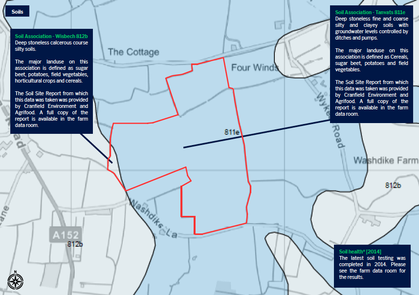
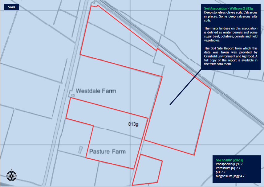
Soil Health Information*
The soil information provided is based on testing carried out in preceding years – the averages stated are weighted across the farms. Details are available in the farm data room.
Land Drainage
Detailed plans are available in the farm data room. The fields that do have under drainage have been drain jetted regularly.
Public Rights of Way
Lot 2 is dissected by a public footpath. Please see a plan in the farm data room of the approximate location/route.
Nitrate Vulnerable Zone
All the fields are within an NVZ – NVZ ID; S669 – NVZ Name; Black Sluice IDB draining to the South Forty Foot Drain NVZ.
Countryside Stewardship Scheme
Part of the property is subject to a Countryside Stewardship Scheme [Mid-Tier] Agreement [1651842] which is in place until 31/12/2028 . This will be transferred to the purchaser upon completion. Please see the farm data room for a copy of the agreement.
Sustainable Farm Incentive [SFI] Scheme
There is an SFI agreement currently in place for part of the Property. This will be withdrawn on completion of the sale.
Tenure and Possession
The property is offered for sale freehold with vacant possession subject to the following holdover requirements and agreements, and the sale completion date. The harvest of maize until 31 October 2026 [Corner Field]. st The harvest of sunflowers until 31 October 2026 [Shoulder of Mutton, Moses Centre]. st The harvest of AHL1 – Pollen & Nectar Mix until 31 October 2026 [Lot 1].
Mines & Minerals
All mines and minerals are included within the sale of the Property.
Rights
The land registered under HMLR Title Number LL89595 has the benefit of a right of way over neighbouring property. The land registered under HMLR Title Number LL382318 is subject to a Deed of Grant to British Gas relating to a gas pipe. The location as such is shown on a plan in the farm data room. The land registered under HMLR Title Number LL300366 is subject to a right of way granted to the owner of the neighbouring property which is subject to shared maintenance responsibilities. Further details are available in the farm data room.
Value Added Tax
If the sale of the land, or any associated rights becomes a chargeable supply in the context of VAT legislation, VAT will be payable by the purchaser[s] at the prevailing rate, in addition to the purchase price.
Location
Lot 1 – What3Words – ///lawns.enjoyable.cactus Lot 2 – What3Words – ///treatment.cost.combines Plans Areas and Schedules The property comprises multiple Land Registry titles. The areas referred to in these particulars are derived from the measured areas of the constituent title parts as downloaded into the Land App and the unregistered areas based on the deeds transferred onto and measured in the Land App. These are shown in the column labelled HMLR Title areas in the land schedule for each field. The LPIS areas on the land schedule are based on RPA data. They are provided for illustrative purposes only.
Boundaries
It will be assumed that the purchaser has full knowledge of all of the boundaries; neither the seller nor their Agent will be responsible for confirming any boundaries or the ownership thereof.
Method of Sale
The Property is offered for sale in two lots by private treaty. It is likely, but not certain, that best bids will be requested as part of the sale process, so if you are interested in making an offer, please make sure that you make this known to the selling agents.