
Latest Leica Geosystems RTK system gives ultra-precise GPS guidance

Farmers looking for an auto-steer system accurate to five centimetres should visit Soil Essentials on stand 1044 at next week’s Cereals Event to see the No Drift mojoRTK tracking system developed in conjunction with Leica Geosystems.
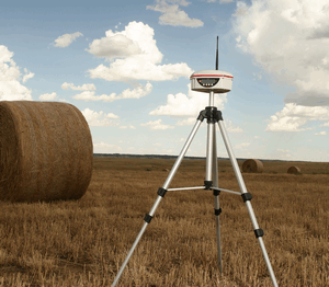
The mojoRTK uses real time kinematic (RTK) technology more commonly used in construction and land surveying to provide an auto-steer system with 5cm accuracy and 99% reliability.
A cordless base station, that can be mobile or fixed, and cab console that slots in to the tractor’s radio port, can be configured for use in about an hour.
The mojoRTK system comes equipped with Virtual Wrench, a remote diagnostic tool that allows Soil Essentials technicians to view the same screen seen by the operator.
Far from acting like Big Brother the remote access enhances operator support allowing Soil Essentials technicians to adjust settings remotely to correct set-up problems or train users.
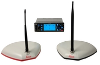
The complete system, including console, base station and Virtual Wrench is on offer for less than £10,000. An upgrade package incorporating GLONASS, which boosts performance by 30% during low satellite times, is also available.
Although the market for RTK systems generally is still very niche, appreciation of satellite guidance systems is increasing according to John Deere’s crop systems specialist Harry Henderson.
Deere currently has about 17 farmers across the
“Standard systems are fine when you travel at reasonable ground speeds, but if you’re in a specialist operation moving at less than a kilometre an hour the smallest amount of satellite drift is significant. RTK systems remove that risk.”
As interest amongst producers grows companies like John Deere are considering ways in which to make the technology more accessible.
“There is talk of establishing RTK networks where the dealer has a base station and licences use of that signal to users,” he said.
