Arctic forecast prompts action on feed

Concern that cold weather is set to return has prompted a relaxation of livestock feeding rules.
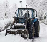
Another blast of severe wintry weather is set to descend on the UK, according to independent risk meteorologists British Weather Services.
The UK will once again be plunged into a protracted period of icy chaos from Sunday (7 February), it predicts.
Senior risk meteorologist Jim Dale said: “Another week to 10 days of ice and snow is on the cards and within that period we will be see temperatures plummet.”
Temperatures would fall as low as -12 deg C in places with the return of disruptive snow in many areas, said Mr Dale.
The snow will initially affect eastern counties of England and Scotland, he added.
But it would become more widespread as the week unfolded, with most areas eventually seeing some significant falls.
“The country can again expect disruption to it’s infrastructure, especially travel, with widespread school closures and possible power outages.”
The forecast arctic weather has triggered the extension of a supplementary feeding derogation for livestock farmers in Wales.
The Welsh Assembly government said it was extending the derogation until 28 February.
It means agri-environment scheme payments will not now be jeopardised by the supplementary feeding of grazing stock when ground is snow covered or frozen
NFU Cymru livestock board chairman said Peter Davies said: “This will be an enormous help as it will allow farmers to give additional feed to their livestock during the cold period.
But farmers should double check the situation with their local Divisional Office as certain conditions would apply to the extended derogation, Mr Davies warned.
The Met Office said the weather after Wednesday (10 February) would be cold with a mixture of bright spells and scattered sleet and snow showers in the north and east.
Strong winds are also expected around some exposed eastern and southern coasts.
Overnight, frost was likely in many places, with locally severe frost inland.
The weather would remain cold for until at least 19 February with some snow or snow showers at times, particularly in eastern and some central areas.
There was also a risk of further bands of rain, sleet and snow spreading into the south of England.

