
New habitat mapping tool to baseline biodiversity
 © Gentian
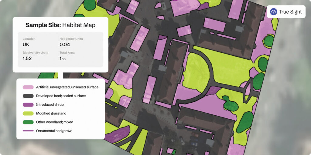
 A fully automated habitat mapping and site screening tool has been launched this week to deliver rapid ecological assessments in just minutes.
Biodiversity mapping data company Gentian announced the launch of the tool, which quickly assesses a site’s baseline biodiversity to understand which areas are best suited for development or biodiversity unit creation.
The tool, known as True Sight, enables landowners, ecologists and consultants to cut down on the costly and time-consuming process of site selection.
See also: Why BNG policy needs to prioritise off-site measures
The tool aims to deliver effective baseline assessments that support early site scoping and selection, at a fraction of the cost.
The platform generates an instant biodiversity unit score, helping users determine whether a site is suitable for development or offers potential for ecological uplift.
It combines recent high-resolution satellite and aerial imagery (at a precision of 12.5cm) with the firm’s proprietary artificial intelligence (AI) engine.
The tool distinguishes individual trees, small ponds, patches of scrub, and other fine-scale habitat features, to deliver accurate habitat boundaries, area sizes and detailed classifications.
With precision technology, landscapes can be accurately analysed to generate habitat maps and biodiversity unit values, providing the data for landowners and ecologists to make confident, informed decisions.
Gentian chief executive Daniel White notes the launch of the tool as a pivotal moment in biodiversity mapping.
“Our solution cuts through complexity, enabling users to assess biodiversity in minutes rather than weeks, and at a fraction of the usual cost.
“It’s about empowering smarter, quicker decisions that benefit both business objectives and the natural environment.”
Whether you need a single survey or ongoing assessments, users can choose between pay-per-use or prepaid credits.
Platform key features
- Fully automated biodiversity assessments Eliminates manual processing to reduce turnaround time for habitat analysis.
- Instant biodiversity unit calculation Delivers rapid and reliable calculations for 10 of the most common habitat types, as well as priority habitats and linear features, including hedgerows and watercourses.
- Unprecedented accuracy Utilising advanced AI algorithms applied to satellite and aerial imagery captured within the past three years, ensuring habitat maps are reliable and up-to-date.
- Seamless integration Allows for real-time data, ensuring speed for planners, developers, and environmental professionals.
- Automatic report generation Instantly generates professional PDF reports containing detailed habitat maps, distinctiveness maps, and biodiversity unit calculations for simplified stakeholder communication and record-keeping.

Need a contractor?
Explore more / Transition
During the series we follow our group of 16 Transition Farmers through the challenges and opportunities as they seek to improve their farm businesses.
Transition is an independent editorial initiative supported by our UK-wide network of partners, who have made it possible to bring you this series.
Visit the Transition content hub to find out more.