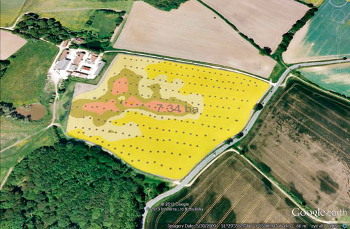
Tool maps young blackgrass plants for pre-em spraying

Researchers have developed a new tool for sprayers that automatically recognises and maps young blackgrass plants within a growing crop, thereby allowing a more targeted approach with herbicides.
Developed by Agrii in partnership with scientists from Syngenta, Reading University and other technology companies, the device is set to become commercially available to growers in four years. Effectively an automated mapping system, it uses image analysis and GPS to plot and register areas affected by weeds.
When commercialised, the tool could be used to map patch spraying, reducing herbicide use and giving growers the confidence they have sprayed the right areas.
“An important area of the project is the process of analysing the geolocated digital images we have been taking in winter wheat in early to mid-June to confirm the presence of blackgrass heads and then creating a map of the weed patches,” explains Carl Flint, an agronomist at Agrii.
Scientists involved in the four-year project say recent developments in image analysis have allowed them to detect weeds, draw detailed maps and then predict future outbreaks.
“The software now allows us to distinguish green from green – blackgrass from cereals – late in the sowing season,” says Alistair Murdoch, a crop scientist at Reading University. Previous software has only allowed the detection of green against brown (weeds against soil).
Dr Murdoch says this system will enable the detection of weeds once the canopy of wheat has closed. Having spotted the weeds, scientists then create a map including a buffer zone of 6-12m for the next season. This allows for both GPS drift and the dispersion of seeds with cultivations.
Unlike previous products, the device is fully automated and consists of a GPS receiver on top of a sprayer combined with a camera on the sprayer’s side shaft. Using the georeferencing system, the sprayer switches itself on and off according to the patch maps.
While various farms have tried out manually weed mapping, Dr Murdoch suggests they have not been very successful.
“Farmers are disinclined to do weed mapping manually using a combine – they’re supposed to be harvesting and forget about the weeds,” he points out. This invention spares them the trouble and could also slash herbicide costs.”
Work is ongoing this season to validate the concept of mapping infestations in one season to determine where to patch spray pre-emergence herbicides in the next season, but early results are promising.
“Seedling counts done last December have demonstrated that summer distribution is a good match to that in a following crop.”
The project is co-funded by the Technology Strategy Board and the mapped field is courtesy of Coppid Farming, Dunsden, Reading.
Visit our Virtual Farm blackgrass resistance page

